
spoke too soon?
The recent lull that has enveloped the Atlantic hurricane basin for the last week or two looks to be coming to an end just as the calendar nears the peak of the hurricane season. With the remnants of quick-lived Jose dissipating over Mexico, the National Hurricane Center is now focusing its attention on two areas of storminess.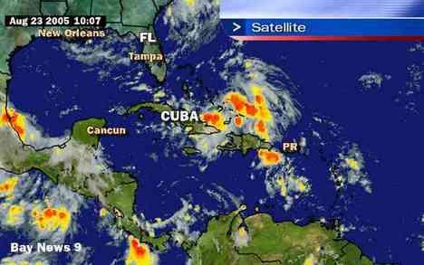
The first area of clouds and showers extend from eastern Cuba and Hispaniola across the Southeastern Bahamas and Turk and Caicos Islands and into the western Altantic Ocean. Forecasters at the National Hurricane Center noticed this morning that the clouds and showers are now more concentrated near the Southeastern Bahamas. To get a better fix of the conditions in and around this area, hurricane hunter aircraft may be dispatched later today to investigate. This weather system is forecast to move eastward and could affect the Atlantic coast of Florida. It is too early to tell if this system will remain a weak tropical wave or develop into something stronger, so resident should monitor the progress of this system closely.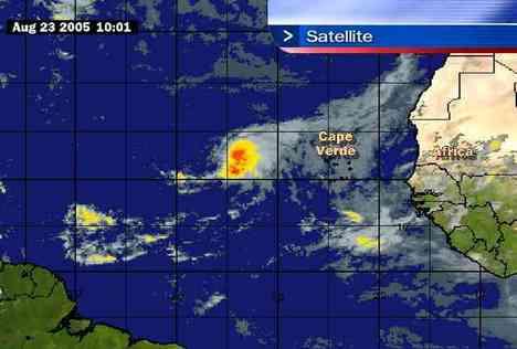
The second area of storminess is associated with a large tropical wave located over the eastern Atlantic 700 miles west of the Cape Verde Island. This wave has the potential to develop into tropical depression during the couple of days as it moves west over the warm, open water of the east-central Atlantic.
hold on folks...this ride could start to get a little bumpy...


11 with their own thoughts:
I know we went through three of them last year - but if they are coming they are going to come - nothing you can do to worry about it. Not sure if I would blog about hurricanes all the time.
*raised eyebrow* i wasn't aware that there were rules for what i could put in a blog about my own thoughts. your suggestion is acknowledged but i think i will continue to blog about whatever's on my mind & i won't force anyone to come here & read it. ;-)
we let Dawn be scared of them for all of us. you and me know we cant do anything about them...but all the fear we dont have Dawn gets...so at least post your name!
yep & you can't tell a person what to be afraid of either, right A?
;-)
Oh boy....
Since a posted as "a" I will post as "b". Just tired of hurricane hype - the term hunker down irritates me along with hyper news people that say "It's over 1200 miles away it looks like it's headed in this direction" UMMMM Yeah.
A posted as A because her name is Andie & i call her A all the time when i'm typing. if you click on the A, it will bring you right to her blog. she's standing up & being herself. and i didn't hype anything. i pulled that advisory right off the NOAA website & the radar images are not sensationalizing--it's fact. all i did was state my thoughts on how i had *just* said things were quiet & now they're stirring up again a bit. my blog, my thoughts. i'm not in the news hyping, i'm just babbling in my little corner of the internet. ;-)
oh for the love of pete...
(((hugs)))
stay safe!!!!!!!
=) thanks Sue!
why is the phrase "For the Love a Pete" haunting me?!?!
it's HAUNTING you Andie???
Post a Comment